
That one time we all went out to Tybee Island and climbed the light house...
(Also, we flew kites!)
(Also, we flew kites!)
Sweet, the eastern most point in the state of Georgia and the place where an Atomic Bomb was accidentally....lost.
Oh, and there's a climbable Light House there to add to my ever growing list. ha. Since we were staying in Savannah for an extended birthday weekend, it only made sense to plan a beach day while we were at it.. And that's how we ended up at Tybee. (as if any of us would complain)

Woo, the Tybee Island Light Station
Opened to the public since 1985.
Opened to the public since 1985.

Info on the Lighthouse as well as the other buildings on the grounds of the little complex.

Tybee Island Light House
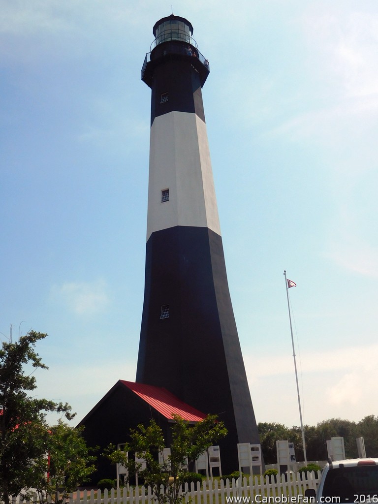
At 154 feet, its the tallest lighthouse in Georgia
Its also the oldest, built just 4 years after Georgia became the final original Thirteenth Colony.
Its also the oldest, built just 4 years after Georgia became the final original Thirteenth Colony.

The original Light was built in 1736, the current in 1867.
(but the 1867 Light uses the base of the 1773 Light!)
(but the 1867 Light uses the base of the 1773 Light!)

Model of the area...
Although, this looks nothing like the current site.
Although, this looks nothing like the current site.

The inner construction workings of the Light.

Woo, lets get climbing!
Right after we got our tickets we were warned that a large group of field trippers were on their way and due to capacity limitations, we should make our climb first and then enjoy the rest of the grounds.
Right after we got our tickets we were warned that a large group of field trippers were on their way and due to capacity limitations, we should make our climb first and then enjoy the rest of the grounds.

So... up we go.
Just 178 steps left!
Just 178 steps left!

Along the way up there are a few windows... but because I didn't wanna ruin the surprise, I made sure not to look. Although I did enjoy them (and the signs and such) on the way back down.

Uh, the beacon, still functioning and still using its original lens.
(a second order Fresnel lens)
(a second order Fresnel lens)

The Light Station complex.

Looking west from the top of the Light

Looking to the north, Hilton Head Island, South Carolina can be seen in the distance.
And the mouth of the Savannah River
And the mouth of the Savannah River

Looking south east toward the city of Tybee Island.
(Where the original Days Inn was located!)
(Where the original Days Inn was located!)

And east itself, the beach and the Atlantic Ocean!

144 feet down from the observation platform...
(the maximum height is 154)
(the maximum height is 154)

Because, well, you gotta have a Jolly Roger flying....

Maannn, that beach sure is inviting...
Fort Screven/Battery Garland is the building in the foreground.
Fort Screven/Battery Garland is the building in the foreground.

Another photo of Fort Screven

Down the stairs... to explore the rest of the little complex.

Clearly, Paul is incredibly interested in being here.

Little garden <3

Yaayyy
(Uh, Photo of the Day?)
(Uh, Photo of the Day?)

Across the street from the Lighthouse is Battery Garland and Fort Screven. We didn't actually explore around here, just in passing to get to the beach.
(everyone else was.. stairs'd out after the Light climb)
(everyone else was.. stairs'd out after the Light climb)

Battery Garland

Uh... Danger what?

And... again, because its so exciting looking.. Battery Garland

Sea life signs... and stuff

Sorry Chelsea, no nudity on the beach.

From the street, there's a short little boardwalk over the dunes to access the beach.

Protected beach dunes

:O Shorebirds guide sign! Sadly, I didn't really see any of them
:(
:(

North Beach
Cleverly named such because its the northern most beach on the island.
Cleverly named such because its the northern most beach on the island.

artsy fartsy
(but it is a neat shot, right? maybe??)
(but it is a neat shot, right? maybe??)

Beach..stuff
OK, time to swim!!!
OK, time to swim!!!

Maannn.... I hadn't been to the beach to swim in far to long.
It was cool-ish but once you got in, it felt amazing and we spent a good few hours just enjoying.
It was cool-ish but once you got in, it felt amazing and we spent a good few hours just enjoying.

This stupid Container Ship passed by us on its way out to sea and made a mini tidal wave that took everyone on the beach by surprised and nearly ruined all of our belongings, had I not been next to our stuff at the time... some of it may have been swept out into the ocean. It was pretty horrifying yet neat to witness.

Yaayyy, the ocean!
Also, also... because I'd never flown a kite before in Georgia..... We alllllll flew kites!
Also, also... because I'd never flown a kite before in Georgia..... We alllllll flew kites!

And since I couldn't find my amazing pterodactyl kite in time... I ended up with this one from Five Below.

Like a Boss.